news

Home / News events / News archive

All events and news in the field of Land management, GIS and Remote Sensing. A contribution to sharing additional knowledge in this area with people working in private and public organizations.

News

New agreement e-GEOS and Planetek Italia
Thanks to the agreement with e-GEOS (www.e-geos.it), Planetek widens its offer of satellite data and services. A...
Sardinia’s flood monitoring service integrates Radar images
SAR Radar images are a fundmental source to support emergency response activities. They can be of great importance, for...
Urban Atlas from the european research to local P.A.
Designed and realized in for the european GMES GSE Land program, Urban Atlas is a Land use Map produced from remotely...
TanDEM-X Launched Successfully, will collect data for global DEM
The German radar satellite TanDEM-X was successfully launched from Baikonur, Kazachstan, at 04.14 hrs CET on Monday,...
ESA Changing Earth Science Network - Call for Research Proposals
The European Space Agency (ESA) hereby invites all interested research institutions, universities and technical...
ESA opportunity for young scientists
ESA is again offering young scientists the opportunity to undertake innovative research projects aimed at advancing the...
Haiti earthquake images
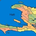
Following the 7.0-magnitude earthquake that hit Haiti on 12 January, international agencies requested satellite data of...
WorldView-2 imagery available from January
DigitalGlobe has announced that its latest high-resolution satellite, WorldView-2, is achieved full operational...

Pages