Παράκαμψη προς το κυρίως περιεχόμενο
en
el
Menu in Greek
H Εταιρία
Σχετικά με εμας
Προφίλ
Ο όμιλος
Eταιρική ταυτότητα
Εταιρική Δομή
Design thinking
Συνεργασίες
Επικοινωνήστε μαζί μας
Γραφεία
Ευκαιρίες εργασίας
Λύσεις
Εφαρμογές
Ανοιχτή Διακυβέρνηση
Έδαφος & περιβάλλον
Διαχείριση καταστροφών
Δασικά & Γεωργικά
Infomobility
μελέτες έργων υποδομής
Eνέργεια κοινής ωφέλειας
Ασφάλεια και άμυνα
Διαστημικές αποστολές
Πλανητική εξερεύνηση
χωροταξία
θαλάσσιες & παράκτιες
περιοχές
Key Topics
Πρόγραμμα Copernicus
έξυπνες πόλεις
Οδηγία Inspire
Ανοιχτά δεδομένα
Sustainable development goals (SDG)
Space segment SW
Ground segment SW
Mission Operations SW
Έρευνα και ανάπτυξη
Παρατήρηση Γης
Eπεξεργασία επί του δορυφόρου
Big data & AI
Κλιματική αλλαγή
Aσφάλεια και άμυνα
Διαλειτουργικότητα
Προϊόντα
Rheticus
Rheticus Displacement
Rheticus Network Alert
Rheticus Marine
Rheticus Map2fish
σειρά SAT
SAT Land
SAT Coast
SAT 3D
SAT Fast
SAT Index
SAT Landslide
SAT Ortho
SAT Urban
Space software
SpaceOP3C
Space SDG
EarthBIT
ERMES
KADMOS
Τα νέα της PKH
Νέα & Εκδηλώσεις
Nea
εκδηλώσεις
GeoXperience
Τεύχη
Multimedia
Video
download
Αναζήτηση
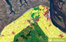
European Coastal Zones data now available
Breadcrumb
Αρχική
-
νέα αρχείο
-
European Coastal Zones data now available
Timeline
2026
Μάιος (1)
Μάρτιος (1)
2025
Νοέμβριος (1)
Οκτώβριος (2)
2024
Οκτώβριος (1)
2023
Νοέμβριος (1)
Ιούνιος (1)
2021
Φεβρουάριος (1)
Ιανουάριος (2)
χρονολόγιο