Expanding the EO services dedicated to aquaculture sector to a new level.
The Aquaculture sector in Europe is highly competitive, while its development is blooming in many other parts of the world. Companies face many costs and challenges which are all the heaviest as the aquaculture sector is dominated by SMEs companies with limited funding capacities.
The sector thus expresses its needs at two levels:
1) There is room to provide support to the optimisation of farming activities (as their costs), like for example:
• aquaculture operations (optimised time at sea, feeding rate dependant of water temperature), regulation duties (anticipate low water quality events), and crisis management (pollution or HAB drift forecast).
• aquaculture development planning and a posteriori environmental analyses/characterisation for licensing or certification including threats and risk assessment (harmful algal blooms, pollution spreading).
2) There is a huge lack of access to funding and investments in particular for aquaculture SMEs. A better image of aquaculture (as promoted by the EU Blue Growth policy) and support in convincing investors and insurance companies, facilitate licensing or certification (site characterisation and environmental impact assessment) could definitely help the aquaculture uptake by the great public and by investors.
During the last few years, a significant number of projects were carried out to promote the use of the Earth Observation (EO) by satellite to the benefit of aquaculture and fisheries sectors. EO can regularly provide synoptic and useful information on the environment (Harmful Algal Blooms or HABs, thermal fronts, water quality) thanks to the Sentinel Programme of Copernicus. However, its stand-alone use is limited as key parameters like local current speed and direction are not retrievable from space. In addition, the spatial coverage of the imagery might be impacted by clouds presence or its quality affected by sun specular reflection.
To expand the EO services dedicated to aquaculture sector to a new level of service, the EOSAI project propose to combine EO data and coastal hydrodynamic modelling.
This will be demonstrated over two sites (one in France and one in Greece) and will allow to get access to current fields to complement diagnostic for farms deployment (Where to put cages with an optimal water circulation? Are the farms vulnerable in case of external pollution? Where are dispersed the farms effluents? etc.) and to offer prognostic on environmental issues (if a HAB or a surface pollution is detected, where will it drift in the next coming hours/days?). Two associations of aquaculture farmers participate in the project; the objective is to pursue the dialogue established in SAFI and SAIMON and to expand the offer to new parameters and new services that would be easy to deploy on any site. Copernicus Programme is providing operationally modelled currents data for all European regional seas and also at the global level.
The EOSAI solution consist on the setup of a set of services and commercial offers tailored for consultancy and aquaculture stakeholders to support their activities and help them gain in competitiveness on the market.
It consists of:
• a unique access point for eased access to environmental data from satellite and models, as well as higher level information derived for aquaculture sector (like harmful algal blooms detection) in near-real time and over long-time series;
• tailored tools to support daily operations (nominal and crisis management) and planning activities (optimal production sites, risks, impact assessment) for consultants and end-users: websites for consultation of environmental characterisation from earth observation and modelling systems, early warning and field reporting systems (smartphone combined with environmental characterisation);
• These solutions will be packed into a comprehensive set of commercial offers with various level of complexity tailored to the customers profiles (farmers, consultants) and to their objectives (spatial planning, certification, licensing, nominal or crisis operations management, etc.).
EOSAI Project objectives are thus to:
1) fully take advantage of the Copernicus Programme datasets (from Earth observation and models) to deploy local hydrodynamic models over two areas of interest (France, Greece)
2) gather existing solutions and tools with new modelling systems into a complete, easily deployable and sustainable service offer for aquaculture stakeholders.
3) improve the exploitation plan and business model prepared in SAIMON and SAFI projects with the EOSAI advances, still ensuring sustainability of the offer
4) assess and quantify the market uptake for the EOSAI service and the derived advanced offers and refine the market strategy for penetration into the European market (intensive and extensive farming models).
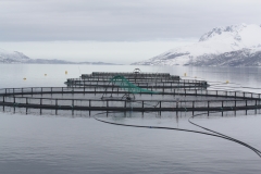
Two sites will be explored in EOSAI project, one in Greece where there is an intensive production (15% of the Greek exported production) and so where there is a balance between environmental footprint and economic consideration (exactly in the same spirit as the Blue Growth strategy). In this area, the Aquaculture Association of Thesprotia participates as End User. The second one is lying on French Riviera and is promoting a very high level of quality in a highly touristic area. In this area, the End User is Cannes Aquaculture. EOSAI is addressing different types of marine aquaculture to make sure that both partners will contribute with its own scientific expertise and culture.
The EOSAI project is realized together by ACRI-HE (prime) and Planetek Hellas.
Project information
Client information:
ESA
Application fields: